


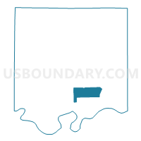
Ward 4, Ray County, Missouri
About
Outline

Summary
| Unique Area Identifier | 609539 |
| Name | Ward 4 |
| County | Ray County |
| State | Missouri |
| Area (square miles) | 11.94 |
| Land Area (square miles) | 11.85 |
| Water Area (square miles) | 0.09 |
| % of Land Area | 99.27 |
| % of Water Area | 0.73 |
| Latitude of the Internal Point | 39.27029580 |
| Longtitude of the Internal Point | -93.91591920 |
Maps


Graphs
Select a template below for downloading or customizing gragh for Ward 4, Ray County, Missouri


Neighbors
Neighoring Voting District (by Name) Neighboring Voting District on the Map
- Camden Voting District, Ray County, MO
- Hardin Voting District, Ray County, MO
- Henrietta Voting District, Ray County, MO
- Ward 1, Ray County, MO
- Ward 2, Ray County, MO
- Ward 3, Ray County, MO
Top 10 Neighboring County Subdivision (by Population) Neighboring County Subdivision on the Map
- Richmond township, Ray County, MO (9,141)
- Crooked River township, Ray County, MO (999)
- Camden township, Ray County, MO (596)